Showing posts with label GPS. Show all posts

Sunday, November 13, 2011

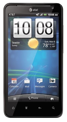
HTC Vivid 4G Android Phone Specs

the gadget

HTC Sense Mobile Experience


With the next generation of the popular HTC Sense mobile experience, the HTC Vivid automatically delivers your most-wanted information to your screen. It offers even more ways to stay connected including FriendStream, which delivers Facebook, Twitter, and Flickr updates in a consolidated view. And you'll be able to pinpoint the location of a lost phone on a map, send a command to make the phone sound an alert even while on "silent" mode through the htcsense.com web site. If needed, you can also remotely wipe all of the phone's data with a single command in addition to forwarding calls and text messages to a different number.


Capture the Moment

Easily capture memories and share them while on the go with the advanced camera capabilities of the HTC Vivid, which offers 8-megapixel camera and Full HD 1080p video recorder. You'll get excellent low-light performance with a backside illuminated sensor and wide aperture lens (f/2.2). Sharing photos to Facebook, Picasa or Flickr is a breeze--and lightning quick at 4G speeds. You'll enjoy video chats over Wi-Fi and 4G connectivity thanks to the front-facing 1.3-megapixel camera.

On the Go Entertainment

The HTC Vivid features HTC Watch--an application and service that puts an entire library of the latest, premium movies and TV shows right at your fingertips. HTC Watch uses progressive download technology that makes it possible to watch videos without waiting for a huge file to finish downloading. You can either rent or buy videos, and if purchased, you can watch them on up to five different HTC devices.

Vital Statistics

The HTC Vivid weighs 6.24 ounces and measures 5.07 x 2.64 x 0.44 inches. Its 1650 mAh lithium-ion battery is rated at up to 5.1 hours of talk time, and up to 250 hours (10.4 days) of standby time. It runs on AT&T's 4G LTE and HSPA+ networks (850/1900 MHz; HSPA+/HSDPA/UMTS) plus international 2100 MHz 3G networks. It's also a quad-band GSM phone (850/900/1800/1900 MHz GPRS/EDGE).

Connectivity

Ultra-fast 4G connectivity via AT&T's LTE and HSPA+ networks. Where 4G isn't available, your phone will connect with AT&T's 3G network.
Wireless-N Wi-Fi networking (802.11b/g/n) for accessing home and corporate networks as well as hotspots while on the go.
AT&T Mobile Hotspot capable enabling you to connect multiple devices from tablets to gaming devices--to the phone's 3G/4G cellular connection via Wi-Fi.
Next-generation Bluetooth 3.0 connectivity backward compatible with older Bluetooth-enabled peripherals and includes stereo audio streaming.
Onboard GPS for navigation (using pre-loaded Google Maps or optional AT&T Navigator) and location services.

Hardware

1.2 GHz dual-core processor speeds up everything--from playing games to watching shows to opening files from work.
4.5-inch qHD multi-touch Super LCD (540 x 960 pixels) with LED backlighting.
HDMI port for video output to your HDTV or monitor (cable not included).
MicroUSB port
Sensors: accelerometer, proximity, light.

Communications & Internet

Full messaging capabilities including SMS text, MMS picture/video and IM instant messaging.
Full HTML browser (Webkit 5) with Flash 10.1 Support
Personal and corporate e-mail access with support for Exchange ActiveSync as well as personal e-mail accounts (Google push, Yahoo!, POP3, IMAP).

Memory

16 GB internal memory
Memory expansion via microSD card slot with support for optional cards up to 32 GB.
1 GB of RAM

Camera

8-megapixel auto-focus camera with dual LED flash and f/2.2, 28mm lens.
Full HD 1080p video capture with recording at 60 frames per second, slow motion playback and on-device trimmer.
1.3-megapixel forward-facing camera for video chats and self portraits.

Multimedia

Music player compatible with MP3, WMA, AAC, and WAV
Video player compatible with MP4, M4V, AVI, WMV, and 3GP.
DLNA capabilities allow you to stream movies, music, and photos from your smartphone to a compatible HDTV.

More Gadget Features

3.5mm headphone jack
Hands-free speakerphone


Saturday, November 5, 2011

GPS Gadget: What You Can Get

These cool gadgets work because of a network of satellites that are constantly revolving around the Earth sending and receiving signals. Your GPS device uses a process referred to as trilateration, that basically involves collaborating with 3 or more of these satellites to see the current coordinates of the device. Basically, it sends an indication out to every of these satellites, and these satellites bounce an indication back. When the receiver gets its return signals, it uses this information to triangulate your exact position.

Whenever we have a tendency to hear the term GPS, what would most likely come back to our minds is a digital device with maps and alternative options that tells us our exact location on Earth. but did you know that such a device is simply one part of GPS? The device is named a GPS receiver, and whereas it's actually a very important GPS device, it's but a region of a awfully large and complicated system that permits us to live our exact location on earth.

The Global Positioning System is a massive and complicated system that will be divided into 3 segments: area, control, and user. The control segment refers to the varied stations on Earth that sustain and management the system. The space segment of the GPS refers to its system of satellites that transmits the signals used for location identification. The user segment refers to the GPS receivers the actual unit that we regularly mistakenly think of as the system.

The control segment of the GPS refers to the varied ground stations run by the US Department of Defense that controls the numerous aspects of the system. Specifically, These stations oversee the flight of the GPS satellites, Synchronize the satellite's onboard atomic clocks and upload the data to be transmitted by the satellites.

The space segment of the GPS is a constellation of twenty seven satellites that orbit Earth 12,600 miles above its surface. 24 of these satellites are in operation whereas the opposite 3 are on standby mode and can be used given that one in all the twenty four fails. Each of the satellites travels around the earth twice in less than twenty four hours, Traveling at a speed of approximately 7,000 miles per hour.

Each of the satellites employed in the GPS configuration weighs between 3,000 to 4,000 pounds. All of these satellites are solar-powered but all have backup batteries onboard to be employed in the absence of solar power (i.e., solar eclipse). The satellites are equipped with tiny rocket boosters to keep them flying on the correct path.

The signals that are transmitted by the GPS satellites are low-powered radio signals. These signals contain 3 completely different sets of data -a pseudorandom code, ephemeris data, and almanac data- that are deciphered by the GPS receiver to get a definite measure of its location. The pseudorandom code tells the receiver that satellite is broadcasting the signal whereas the ephemeris data provides information about the satellite's position. Meanwhile, the almanac data contains information like the standing of the satellite current date and time.

The user segment of the GPS refers to the GPS receivers, used for either military or civilian purposes. The GPS receiver is essentially an electronic device that picks up the signal transmitted by the satellites and uses the knowledge on those signals to work out its precise location. Of course, This operate is way more advanced than a straightforward summary makes it sound.

The GPS receiver in fact desires two things for it to determine its location. First, it desires information to tell it the placement of a minimum of 3 GPS satellites. Then, it would have to be compelled to measure the length between it and each of the 3 GPS satellites. The primary information may be interpreted from the signal transmitted by the satellites whereas the second set of information may be obtained by measuring the speed at that the signal was received.

Combining the management space and user segments, We've got a Global Positioning System that may reveal our precise location here on earth.

As you'll see, the GPS isn't solely the GPS receiver alone. It's an immense system and a awfully advanced one at that but because each alternative part of the system is well maintained by the Department of Defense, We must always never have to worry about those parts. All we have a tendency to must do is secure a GPS receiver and in a moment, We'll receive information about our current location and alternative landmarks and road conditions that the receiver might want us to understand.

Tuesday, November 1, 2011

Garmin GPSMAP 696 Color Portable Aviation

“gps”

Meet our ultimate portable MFD: the GPSMAP 696, an all-in-one navigator designed exclusively for aviation. Featuring a large screen, detailed electronic charts and real-time weather, the 696 is your own personal avionics system.

The GPSMAP 696s bright 7-inch diagonal high-definition sunlight-readable display makes detailed mapping easy to see day or night--you can even view an entire approach plate on the large-format display. For easy operation, the bezel around the screen includes soft keys and a joystick control. And with a fast 5 Hz GPS update rate, the 696 renders graphics and presents flight data smoothly and continuously.

No Chart? No Problem.
With the addition of Garmin FliteCharts and IFR map mode, the GPSMAP 696 provides key functions of a Class 1/Class 2 electronic flight bag (EFB), reducing the use of paper charts in the cockpit. With FliteCharts, you can quickly find and view all U.S. NACO departure procedures (DP), standard terminal arrival routes (STARs), approach charts and airport diagrams. If the current approach is known, GPSMAP 696 automatically selects the correct chart based on the flight plan. When in IFR map mode, the 696 can display victor airways, jet routes, minimum enroute altitude and leg distance, much like found on paper enroute charts.

Add Weather and Radio
The GPSMAP 696 includes a GXM 40 smart antenna, which gives you access to high-resolution weather and audio entertainment right in the cockpit (XM subscription required). XM WX Satellite Weather includes next generation radar (NEXRAD), aviation routine weather reports (METARs), terminal aerodrome forecasts (TAFs), temporary flight restrictions (TFRs), lightning, winds aloft and more for the U.S. and Canada. In addition, the 696 can receive PIREPs, turbulence forecast and icing forecast information. The weather data can be laid directly over the unit�s navigation and topographic map databases. With 170+ channels of digital music, news and programming through your aircraft headset or cabin audio system, you�ll stay informed and entertained.


Enhance Situational Awareness
The GPSMAP 696 features a high-resolution terrain page showing hazards relative to your altitude and a vertical profile of terrain along your route of flight. It comes with a built-in Jeppesen database, and an Americas, Atlantic or Pacific terrain database. It also includes an obstacles database for the U.S. or Europe. Using this information, the 696 displays your flight route over contour terrain mapping. With information from the terrain and obstacles databases, the 696 monitors your current position in relation to surrounding terrain to provide alerts. To help keep pilots aware of special airspace activity, over 683 parachute drop zones are detailed in the Americas navigation database. You can even customize your own minimum clearance levels to receive terrain cautions. The 696 also comes with a realistic "view from space" satellite imagery basemap.

Like other portable Garmin devices, the 696 includes the following enhanced aviation databases:

Garmin SafeTaxi
Provides detailed taxiway diagrams and position information for over 850 U.S. airports. Preloaded on the device, this information helps you navigate unfamiliar airports with confidence and shows your aircraft's exact position on the field.

AOPA Airport Directory
Offers detailed information for over 5,300 U.S. airports, along with the names and phone numbers of thousands of FBOs. Easily look up taxi services, plan an overnight, and choose fuel stops, plus find ground transportation, lodging, restaurants, local attractions and more.

Private Airports and Heliports
Provides data on private airports and heliports throughout U.S. and Europe, and materially expands your list of navigation and emergency "nearest" options.

Receive Altitude-Sensitive Alerts
When in the air, Garmin's new Smart Airspace feature makes it easier than ever to identify what airspace lies ahead. Smart Airspace automatically highlights airspace close to your current altitude and de-emphasizes airspace away from the current altitude, which gives you increased situational awareness.

Expand Your Portable
The GPSMAP 696 includes an SD card slot for extra memory and updates. Keep track of the databases on your GPSMAP 696 through www.fly.garmin.com, our online manager that helps you update, manage and purchase the latest aviation data for your Garmin device, all in one place.

Master the Basics with eLearning
To gain quick familiarity with all the features and operation of your GPSMAP 696, Garmin offers a fully interactive, computer-based training program on CD-ROM. It's called the eLearning Program, and it's a self-paced, Windows compatible application developed in conjunction with Pegasus Interactive to help new users take advantage of all the capabilities their GPS unit offers. Available from authorized Garmin dealers or directly from Garmin.com, the eLearning program for your GPSMAP 696 lets you select specific topics of interest, and then learn by doing. A scenario-based guided simulation system helps you practice the selected task or process by following step-by-step, on-screen prompts. You'll see a simulated multi-media demonstration; then repeat what you�ve learned, hands-on, to reinforce and assess your skills. Getting started with Garmin eLearning is the fast, fun way to master your new portable GPS.

Americas Terrain Database
Enhance situational awareness with the Terrain Aviation Database. This digital database contains the elevation data which represents the topography of the earth. Using this information, your Garmin aviation GPS monitors your current position in relation to surrounding terrain to provide alerts--giving you additional time to make critical decisions regarding the flight path. Since Terrain data does not include man-made objects (towers, airports, VORs etc.), updates to Terrain data do not occur on a regular basis.

The download process for Terrain updates is simple and convenient. Simply plug in your aviation device, download and go.

Jeppesen Database Information
The GPSMAP 696 includes an internal Jeppesen database that provides location and facility information for thousands of airports, VORs, NDBs, and more. Updates to the Jeppesen database are available every 28 days online. The following information is provided:

Airport--Identifier, facility name, city/state/country, latitude/longitude, field elevation, available fuel types, runway designations and layout, runway surface, runway length, runway width, runway lighting, communication frequencies, and published approaches.
Weather--Frequencies associated with an airport (ASOS, ATIS, and AWOS).
VORs--Identifier, facility name, city/state/country, location (latitude/longitude), frequency, service volume (high, low, terminal), and type (such as VOR-DME, TACAN, and VORTAC).
NDBs--Identifier, facility name, city/state/country, location (latitude/longitude), and frequency.
Intersections--identifier, nearest VOR, radial and distance from nearest VOR, location (latitude/longitude), and region/country.
ARTCC--Air Route Traffic Control Centers.
Airspace--boundaries (Class B, Class C, Control Zones, SUAs, and MOAs), controlling agency, and vertical boundaries.
FSS--Flight Service Stations.